Morning sights around the campsite
Hitting the trail early
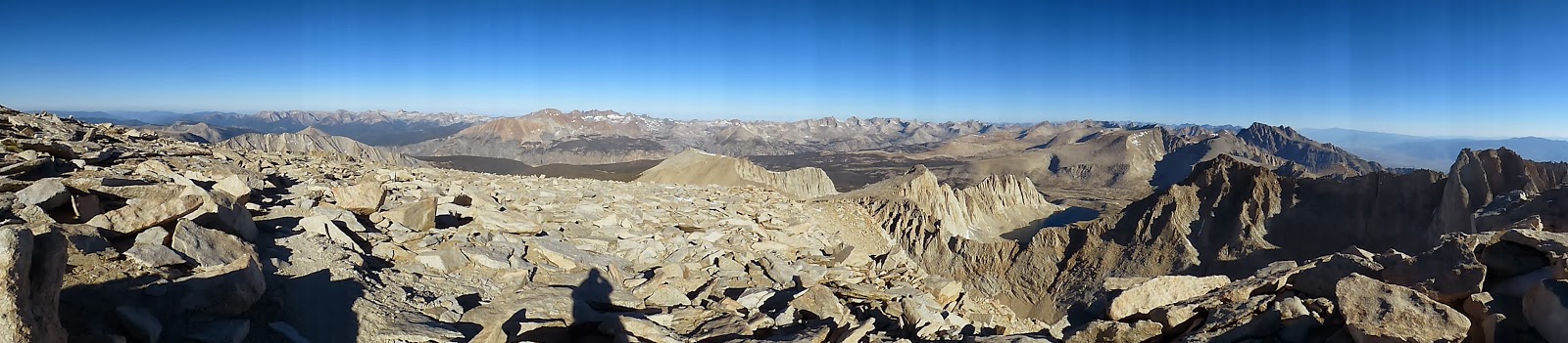
We woke up early on this day because we wanted to hit Forester Pass early on, then keep hiking and go on to Whitney. We woke up, John bandaged my poor feet, we got ready, broke camp and hit the trail at 6:40 a.m. It was really cold this morning--probably around 30 degrees or so. So we were bundled up when we started. The terrain was rolling at first then just uphill. Up, up, up we went. This pass wasn't difficult, thank goodness, as far as finding the trail goes. There was little to no snow. We camped pretty high up so we only had to ascend a little over 1000 feet elevation over the course of a couple of miles. I, of course, counted my steps 1-20 over and over again so I could make it up the pass. After awhile we made it, all 13,200 feet that is Forester Pass! It was beautiful up there. It's so cool to stand at the top of a pass and look down and see everything you just climbed up. All that you just conquered. Very empowering. Then you remember you have to go a very long way down and your feet hurt the worst going down. But nonetheless, an accomplishment and our last pass!!

Heading up to Forester Pass
Panoramic at the top of Forester
Looking back down
The sign at the top of the pass
Beautiful, looking back down
John at the top
7 mountain ranges, many (if not all) that we surely hiked over
Us at the top (I'm just a little excited)
After resting for a bit we started the descent. We descended all the way down to 10,500 feet. Lots of walking along barren plateaus. This wasn't my favorite scenery that we'd encountered. Anyway, hike hike hike. Vegas hiked with us again on this day but was a bit ahead of us since I'm super slow on descents. We saw him around lunch, eating with some guys he'd just met. We told him we were planning on eating at Crabtree Meadows (4.4 miles later and the last place you can go #2 before summiting Whitney) and we would just see him there or at Guitar Lake (the last water source before summiting Whitney). Those 4.4 miles seemed to go on forever; we were both ready for a break. We finally arrived and trucked it over to the "toilet". It was a toilet lid on top of a latrine with two walls partially covering. Two walls, not four...so awkward since it's in the middle of a meadow but whatever, it worked.
Some of the trail on the way down
Me hiking through a plateau
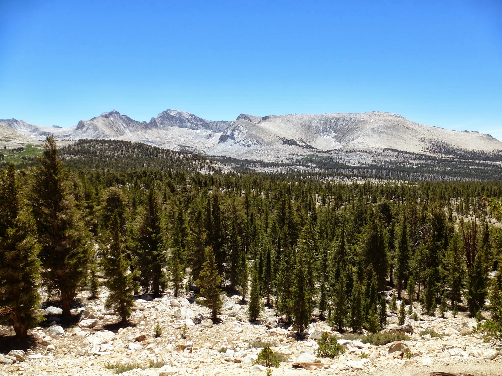
Before all of this we hiked through Big Horn Plateau (which was pretty but felt like it went on
forever) and that's where we got our first look at Mt. Whitney! It seemed so close but we knew we still had a long ways to go. Anyway, Crabtree Meadows, we ate lunch, filled up on water and got going shortly after because we didn't have time to waste if we were going to try and summit Whitney that night.
About to enter Big Horn
Panoramic of Big Horn
First Mt. Whitney sighting! (to the left)
Me hiking through Big Horn
A better look at Mt. Whitney
We started hiking to the base of Whitney and a few couples we passed asked if we were hiking with another guy and said he was looking for us. We thought Vegas was behind us since we hadn't seen him at Crabtree but now he was ahead of us so we had to catch up with him so that we all had our game plan straight. We continued to hike up the moderate ascent and every person who passed us asked if we were hiking with Vegas and said he was looking for us. We know, we know! We're trying to catch up with him! But my energy was fading because we had been hiking for about 11 hours at this point. Finally a man told us that Vegas was waiting for us at Guitar Lake. Ok good, now we knew where he was and that we would catch up to him. The same man also told us he didn't think we could make it to the top of Whitney tonight and that we should camp before we got there. Haha! John was already on a mission, now he was even more so!
Starting to head up Mt. Whitney
So, shortly after we met up with Vegas at Guitar Lake (last place to fill your water for the rest of the summit to Whitney and most of the way back down). John filled up both nalgenes and our 64 oz. water filter bag. While he finished that I started hiking because I was the slowest; I knew they would catch up with me. And they did, eventually. Hike up, up, up. The uphills switched from moderate to super steep to moderate. Until the hellacious switchbacks. They were so steep and seemed to go on forever! I thought I wasn't going to make it. I was fading fast (13 hours of hiking at this point) but this was it! This was Mt. Whitney, the very last thing I had to climb! The official end of the JMT (even though you have to descend 10 miles down the other side to actually get to civilization). I
had to keep going. So we did.
Guitar Lake
One of the views heading up Whitney
The trail going up Whitney
Beautiful view and more trail
The last junction before the last ascent (let me tell you, that last 1.9 miles is no joke)
Up, up, up. The scariest part was right after the last junction, the sun was setting and the trail was getting extremely steep, jagged and rocky. I kept thinking that I was tough and strong and darn-it if anything was going to keep me from summiting Mt. Whitney tonight! And so the sun set, the full moon came out and so did our head lamps. I am extremely thankful for the Lord's protection and John's guidance up to the very top of the summit. I looked at my watch, 9:30 p.m., we made it!!
Fifteen hours of hiking, 23 miles of trekking through terrain and we were on the top of the highest point in the US outside Alaska!!! And we had reached the official ending point of the JMT! We did it! Two hundred and ten miles we hiked and persevered through and conquered! I was amazed that I had completed this. I felt like I could do anything because I had just finished hiking 210 miles of uphills, downhills, creek crossings, snow covered mountains and trails, steep switchbacks, past rattlesnakes and up mountains whose elevations made my head swim!
We did it!
Famous spires leading to Whitney (trail in lower right corner)
John at the last junction
No shortage of beautiful scenery
More trail heading up Whitney and the moon
Amazing
Trail
Looking down (which I tried really hard not to do)
And now time for bed because it was late and the elevation made me feel funny. Mt. Whitney stands at 14,500 feet tall. The reason we wanted to summit on this night was because we had heard the sunrise was amazing and we didn't want to battle the crowd on the way up in the morning. So we slept at the top of a 14,500 foot mountain, higher than anyone in the lower 48 states that night. But I didn't sleep long or well for whatever reason--my feet being in extreme pain, the elevation, the wind.
Incredible colors
The sun setting while we continue to hike to the top
Still going up...
John posing with the official marker at the top
Getting ready to set up camp for the night
Total JMT miles: 210